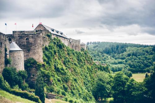
디넝(dinant), 시타델 (citadel)

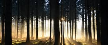
The Ardennes, situated in the south-east of Belgium, are one of nature's unspoilt areas, rich in fauna and flora, with vast forests of broadleaf and fir, hills and fast flowing rivers. Visitors can wander through the many picturesque villages nestling in the valleys where traditions and folklore still live on, and where the region's arts and crafts can be enjoyed.

Frahan (Belgium), the Semois river and the village seen from the point of view alongside the Alle road at Rochehaut.
The Ardennes (French: Ardenne [aʁdɛn] ⓘ; Dutch: Ardennen [ɑrˈdɛnə(n)] ⓘ; German: Ardennen; Walloon: Årdene [ɑːʀdɛn]; Luxembourgish: Ardennen [ɑʁˈdænən]), also known as the Ardennes Forest or Forest of Ardennes, is a region of extensive forests, rough terrain, rolling hills and ridges primarily in Belgium and Luxembourg, extending into Germany and France.
Geologically, the range is a western extension of the Eifel; both were raised during the Givetian age of the Devonian (382.7 to 387.7 million years ago), as were several other named ranges of the same greater range.
The Ardennes proper stretches well into Germany and France (lending its name to the Ardennes department and the former Champagne-Ardenne region) and geologically into the Eifel (the eastern extension of the Ardennes Forest into Bitburg-Prüm, Germany); most of it is in the southeast of Wallonia, the southern and more rural part of Belgium (away from the coastal plain but encompassing more than half of the country's total area). The eastern part of the Ardennes forms the northernmost third of the Grand Duchy of Luxembourg, also called "Oesling"
(Luxembourgish: Éislek). On the southeast the Eifel region continues into the German state of the Rhineland-Palatinate.
The trees and rivers of the Ardennes provided the charcoal industry assets that enabled the great industrial period of Wallonia in the 18th and 19th centuries, when it was arguably the second great industrial region of the world. The greater region maintained an industrial eminence into the 20th century, after coal replaced charcoal in metallurgy. The strategic position of the Ardennes has made it a battleground for European powers for centuries; it was the site of major battles during both World Wars.

Rock Bayard of Dinant, on the right bank of the Meuse. According to a legend, a magic horse jumped from the top of this rock to the left bank of the river, carrying the Quatre Fils Aymon fleeing Charlemagne.

디넝(dinant), 시타델 (citadel)
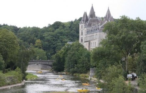
Dinant city. It is a pretty setting at the edge of the Meuse with the citadel dominating the city


Dinant with the medieval Citadel and the Collégiale Notre-Dame

Beautiful nature in Belgian Ardennes


Walzin Castle is located in Dréhance, south of Dinant, in the province of Namur
Walzin Castle is one of the largest in Belgium. Perched at the top of a 50m-high cliff, it overlooks the River Lesse.


The authenticity of the Belgian Ardennes

HauteSure_

De Éislek, de Ardennen in Luxemburg
Treasures of Belgium # 20 - The Ardenne

The Ardenne
It is a Belgian, French, Luxembourg and German natural region situated to the east of the Meuse and the Sambre and bounded on the south by the plains of Lorraine and Champagne.

This historical region encompasses the geological regions: the Fagne, the Famenne, the High Fens, the Eifel, the Oesling, the Calestienne, part of the Condroz. The Ardennes massif is an ancient mountain.

Arduenna is the name, probably of Celtic origin, of a forest located on and around the massif of the Ardennes. Some modern authors defend the black color as meaning (from the Celtic Ar'Den meaning "the dark").
Today, the names Ardenne and Ardennais are used in the names of natural or administrative territories which are located on the old forest, crossed by the Meuse. It is sometimes difficult to recognize the boundaries of these territories, especially since the many attempts at appropriation of this name entertain some confusion.
Normally, when one speaks of the territory, the term "Ardenne" (singular) is used to designate the Belgian Ardennes a region which is composed of provinces and is not an administrative entity, as opposed to "the Ardennes" a name that designates an administrative department in France, or the tourist complex of an ill-defined region (Franco-Belgian, even Franco-Belgo-Luxembourg).

History
The Ardennes were populated since the Iron Age (-800) by the Gauls (Celts). The first Latin quotations of this Arduenna silva are found in the account of the war of the Gauls of Julius Caesar. Caesar, who spent a short time there, described the Ardennes forest as having a length of 500 Roman miles (about 700 km), crossing the country of the Treviri and extending from the banks of the Rhine to the country of the Nervians and Remi.

Geography
From the point of view of geography, the Ardennes corresponds to the rugged forest territory limited to the south by Lorraine and Champagne, to the west and to the north by the furrow marked out by the Sambre and the Meuse, by the Famenne and the Hesbaye , to the east by the Eifel volcanic region which runs along the Belgian and Luxembourg borders between Aachen and Wasserbillig. The greater part of the Ardenne is in Belgium, exclusively in the Walloon Region.
It also covers the northern part of Luxembourg called the 'Oesling'. The Ardennes culminates at 694 meters, at the signal of Botrange in the Hautes-Fagnes of the province of Liège. The Ardennes forest is formed of fragments of the former coal forest.
Hydrography
The Ardennes is a place where many rivers originate, such as the Lesse, L'Ourthe, L'Amblève and the Sûre.
The region is crossed by a single important river, the Meuse, at its western end. However, other important rivers delimit its borders with the Eifel region such as the Moselle and the Rhine.

The highest peaks
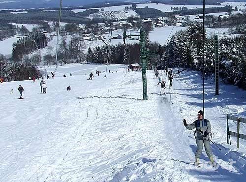
Where bottom skiing is practiced when there is snow, which is becoming less frequent ...
Le Signal de Botrange 694 m
Summit of the High Fens, Province of Liège
Weisser Stein 692 m
Mürringen, Province of Liège
La Baraque Michel 674 m
Province of Liège

La Baraque de Fraiture 652 m
Top of the plateau des Tailles, Province of Luxembourg
The locality Galata 589 m
Top of the plateau of Saint-Hubert, Province of Luxembourg
La Croix-Scaille 504 m
Where stands the Millennium Tower, Province of Namur, on the French-Belgian border

Climate
The summers are hot and humid, the winters are cold and long. The climate is mainly influenced by the relief of this massif. Temperatures in the Ardennes are lower than in the surrounding regions because of altitude. As it rises, the air cools, causing a loss of about 0.7 ° C every 100 meters. In an anticyclonic situation, the temperature may be higher than those in the plain (inversion of temperatures).
The forest massif also contributes to this temperate climate. This vast forest cover captures much of the solar radiation, preventing the increase in soil temperature. The air heats up less quickly than elsewhere. The opposite phenomenon also exists: at night, the trees prevent night radiation, resulting in a sharp decrease in temperatures.
In the valleys, the relief makes it possible to protect from the wind some places while exposing others located more on the heights.
'Wonderful World' 카테고리의 다른 글
| 20 classic American landmarks to see in US (0) | 2023.12.25 |
|---|---|
| The Ardennes (Belgium) (0) | 2023.12.19 |
| Ilha de São Miguel nos Açores (0) | 2023.12.18 |
| Ilha de São Miguel, Açores, Portugal (0) | 2023.12.18 |
| Amazing Grace ~ Highland bagpipe & Hayley Westenra (0) | 2023.12.15 |