Te Pito Kura, the navel of light
AHU TE PITO KURA - The navel of light | Imagine Easter Island
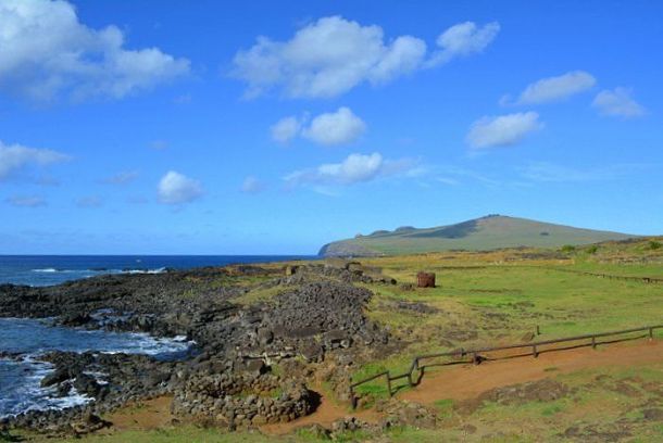
Te Pito Kura is located on the north coast of Easter Island. Over its platform was erected the largest moai transported from the Rano Raraku volcano quarry.
imaginarapanui.com
Paro moai, the largest statue ever raised over an ahu

Moai Paro in Te Pito Kura with the Poike volcano in the background
Te Pito Kura is an archaeological complex located in front of the Bay of La Pérouse, about two kilometers southeast of Ovahe beach. In this ceremonial center is the Ahu or Paro, whose only moai named Paro, remains in the same position it was when it was demolished almost two centuries ago.
The Paro Moai represents a milestone from the period when the statues were built, as it is the largest moai statue transported from the Rano Raraku volcano quarry and erected successfully on an ahu or platform. Its dimensions are spectacular: its ears measure 2 meters, its height reaches 10 meters and it is estimated that its weight must exceed 80 tons.
The moai lies face down and his body is splitted in half as a result of his collapse. In front of his head lies its gigantic pukao, almost 2 meters high and about 10 tons in weight, considered also one of the most voluminous headdresses carved and transferred from the quarry of Puna Pau.
According to tradition, it was a widow who commissioned the construction of this moai, in memory of her late husband. It seems that the moai Paro would have been one of the last statues to be knocked down from his ahu. It is believed to have occurred shortly after 1838, since after this date there are no records of the visitors seeing a standing moai.
Te Pito O Te Henua , “navel of the world”.
The magnetic stone

The magnetic stone of Te Pito Kura
Next to the ahu, a few meters away, is a large ovoid shaped stone 80 centimeters in diameter. The expression Te Pito Kura means “navel of light” and some people relate the name of the place with the special qualities of this rock and with one of the names with which it is known to Easter Island, Te Pito O Te Henua which means “navel of the world”.
This singular stone was formerly known as Tita’a hanga ‘o te henua, and according to legend, was brought by Hotu Matu’a, the founding king of the Rapanui people, in his boat from Hiva, his native land. It is said that this rock, almost spherical and smooth, concentrates a magnetic and supernatural energy called mana.
Because of its high iron content, this stone warms up more than others and causes the compass to behave strangely. Many visitors put their hands on it to capture their energy or also, according to the belief of some, increase female fertility. It seems that some tourists, too believing in their power, performed some obscene act on the stone and since then they decided to close the circle of stones that surrounds it.
Very near here, close to Hanga Ho Onu, the Ahu Heiki’i is found, oriented according to certain stars, and that contains among its vestiges three pukao. It is the largest ahu on the island, stands out for its size and imposing appearance and has beautiful petroglyphs. In this area there are several hare paenga (boat houses), umu pae (cooking ovens) and a pipi horeko (stone landmark) that was used to demarcate the place.
How to get to Te Pito Kura
From Hanga Roa you can get there by car on two routes. The fastest is to take the road that crosses the island in the direction of Anakena. Just before reaching the beach, turn right at the junction in the direction of Poike. About 2 kilometers after the diversion of Ovahe you will arrive near the La Pérouse cove, where there is a small parking lot.
The other option is to take the road that borders the south coast in the direction of Tongariki. Continue leaving the Poike hillside to the right and take the curve to the left to advance along the north coast road. Te Pito Kura is located about 3.5 km from this curve after passing through the site of Pu o Hiro and the petroglyphs of Papa Vaka.
Location Map


'Wonderful World' 카테고리의 다른 글
| Mount Kangrinboqê(Gang Rinpoche or Mount Kailash) & Lake Mansarovar(Mapam Yumtso) (0) | 2023.11.26 |
|---|---|
| The Navel of the World or Earth - the axis mundi or world axis (0) | 2023.11.22 |
| Navel of the World or Navel of the Earth (0) | 2023.11.21 |
| Aotea/Great Barrier Island tour (0) | 2023.11.20 |
| Auckland’s Great Barrier Island (0) | 2023.11.20 |